The Exchange
Wednesday, August 03, 2016
By Caroline Njoroge
The Kenyan government is seeking the United Nations’ Commission on the Limits of Continental Shelf (UNCLCS) to map out Kenya’s territorial waters to enable the country exploit huge oil, natural gas and mineral reserves believed to be underneath the Indian Ocean sea bed.
Attorney-General Githu Muigai on Monday told the New York-based United Nation mandated to determine countries’ maritime boundaries, to fast track the demarcation of the sea borders to pave the way for Kenya’s search for riches in her territorial waters.
“We want the commission to map out Kenya’s outer limit of its continental shelf (the line between Kenyan waters and international waters) to enable Kenya to start exploration for oil gas and rare minerals within its sea,” said Prof Muigai.
Under the UN Convention on the Law of the Sea (UNCLOS), also known as the Law of the Sea Convention, a coastal state like Kenya has sovereign rights to explore and exploit, conserve and manage the natural resources in its Exclusive Economic Zone (EEZ).
Such a zone extends to a maximum of 370 kilometres (200 nautical miles) from the edge of the territorial sea.
However, the UN Convention provides that countries with opposite or adjacent coasts must de-limit their zones by applying international law to avoid conflict with other nations.
The AG said Kenya wants a speedy delineation of what is technically referred to as outer continental shelf limit as provided by the Law of the Sea Convention; The continental shelf of countries with sea borders is the natural extension of its land territory in to the sea.
Waters row with Somalia
Kenya is separately battling a court case before the UN’s top court over a maritime border dispute with Somalia after the latter mentioned nation lodged a case with the ICJ in August 2014 seeking to reclaim an area of the Indian Ocean bordering Kenya’s territorial waters..
The AG said Kenya would be arguing its case against Somalia’s claim next month in The Hague.
The Hague-based UN court was set up in 1945 to rule on disputes between member-states of the United Nations.
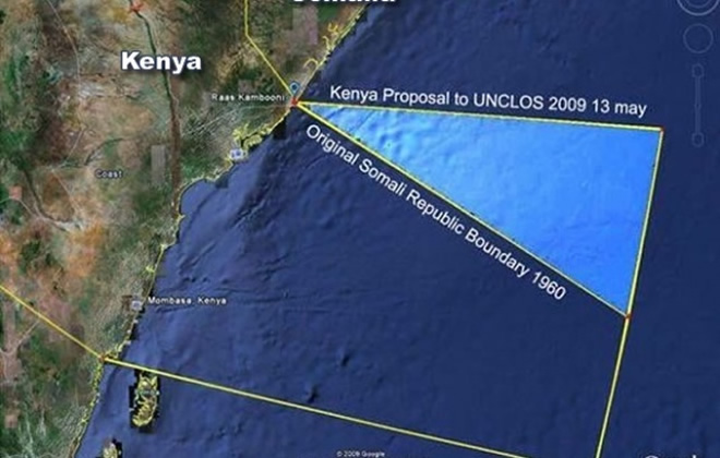
Somalia’s claim threatens to take away about 64,000 square kilometres from Kenya’s territorial waters, including part of the Lamu oil exploration basin.
In 2009, Kenya and Somalia signed a memorandum of understanding that the border would run east along the line of latitude, but Somalia, which has lacked an effective central government since 1991, then rejected the agreement in parliament.
By prompting Somalia to enter into the MoU with it in 2009, Kenya was trying to meet a May 2009 deadline set by the UN Commission on the Limits of the Continental Shelf (UNCLOS), which required countries to submit agreements with neighbouring states on the limits and orientations of their maritime boundaries.
For Kenya, the MOU had settled matters once and for all. Nairobi officials believe that the April 2009 agreement signed by then-Kenyan Foreign Affairs Minister Moses Wetangula, and his former Somali counterpart, Abdirahman Warsame, allowed Kenya – not Somalia – to officially demarcate its maritime borders to include the approximately 200 nautical miles off the coast of the Horn of Africa. More precisely, for Nairobi authorities, the MOU extended the Kenyan boundary east to approximately the 45° line of latitude.
Kenya, however, wants the sea border to go in a straight line east, giving it more sea territory.
The area which stretches 100,000 square kilometres has great potential reserves of oil and gas stretches.
“The matter will come up in September for Kenya to argue a preliminary point, that is that the court has no jurisdiction over the matter as Kenya and Somalia in 2008 agreed on a system of dispute settlement, namely diplomatic negotiations,” said the AG.
It has requested the court “to determine, on the basis of international law, the complete course of the single maritime boundary dividing all the maritime areas appertaining to Somalia and to Kenya in the Indian Ocean, including the continental shelf beyond 200 nautical miles.”
Kenya has in the past raised preliminary objections to the jurisdiction of the court and the admissibility of the application.
Somalia’s application to the court says the two countries “disagree about the location of the maritime boundary in the area where their maritime entitlements overlap” and says diplomatic efforts have failed to broker an agreement.
Kenya has already licensed several companies to prospect for oil in the disputed patch of the ocean as part of its ambitious plan to search for oil and gas both on- and off-shore.
Kenya has mapped out 44 oil and gas exploration blocks, licensed to 23 international oil companies and one to the National Oil Corporation of Kenya.
They include Total, Eni, Anadarko, BG Group, Apache Corporation, Origin Energy and Pancontinental of Australia, which discovered vast gas reserves in Block L8 in the Lamu Basin in September 2012 and oil in June in the same basin.
The UN law of the sea asks states with shared coastlines to agree on the extent of three different areas, their territorial seas, exclusive economic zones and continental shelves.
Launched in 1982 and signed by 130 countries by 1994, UNCLOS seeks to establish the sea limits and sovereignty of states on the use of the sea and allows coastal countries to seek an extension of their exclusive economic zones beyond the 200 nautical-mile limit.
Since Somalia had rejected the MoU with Kenya, the UN refused to endorse it, terming it “non-actionable” on March 12, 2010.
After declining Kenya’s overtures, the Somali government filed a case in the International Court of Justice in February.